I like books with maps in the front, and since you’ve found a way to a publishing website that primarily focuses these days on fantasy and science fiction, there’s a good chance that you share my opinion. Although I’m not a reader who spends hours pouring over the maps at the front, trying to chart out the course that the characters took, or catch the author in a continuity mistake regarding the reasonable travel time between two cities, I do consider a map in the front as a sort of mark of merit. If the author went to the time and trouble to have a map included, then there’s a better chance that it’s a book I’m going to want to read.
As I’ve worked on my writing, I’ve had a conflicted relationship with maps. In high school, I went on a world-building kick, where I would spend weeks and months creating maps, religions, ecosystems, histories, and magic systems for a new world, and then find that I had no plot or characters, no story to tell in the world that I had just created. After high school, I got away from such intensive world-building, and focused more on the actual writing, mostly world-building in my head or along the way. This, I found, was much better for me, since my art skills are rather lacking, and I can hold the story comfortably in my head without needing to slow down every other paragraph to reference my world creation documents. Some authors start out their stories by drawing a map, but that’s not how I do it.
It wasn’t until I started working on publishing the Blood Magic series on the site that I saw a need to return to map-making and really detailed world-building. I did some research about modern cartographic techniques, consulted a few images of real-world maps, and essentially replicated the same figures, but changed the continents and the oceans and of course the names. The world of Blood Magic is fairly Earth-like, including the usual north, south, east, west system of cardinal directions, and similar dimensions, so this worked well enough; it was only really intended to give readers (and me) a general idea of where things were in the world. You can see the Blood Magic map on the main page for the series.
A little after that, I was sitting down to work on the second Fo’Fonas novel, after having left that world behind for awhile, and I realized that for a work of this scope I was going to need better world-building materials than what I could keep track of in my head. I found myself spending more time going back and searching for obscure references that I made in the first novel than I was spending actually writing the second one. This was when I hit upon the format for really substantial world bibles, and I also knew that I was going to need a map. However, I wanted this to be an in-world map, and the Fo’Fonas world is much less Earth-like than the Blood Magic world.
Instead of looking at modern maps, I researched the history of maps, and how the world has been depicted throughout human history here on Earth. At the time, there was a poster of an old-style map in the hall of where I was working. It had two main circles, and the outside of those circles was filled with drawings and icons and extra information, like information on the phases of the moon. This became my primary inspiration for the Fo’Fonas world map, but my artistic abilities weren’t up to the complexities, so I settled for just the core map. You can see the Fo’Fonas world map in its current for on the main page for that series.
From all of that research, I came up with three major takeaways: first that ancient world maps were more works of art and political statements than they were useful navigational tools, second that ancient maps usually overstated the amount of landmass compared to the amount of watermass on the planet, and third that ancient maps were enormously varied in shape, size, orientation, and accuracy. My Fo’Fonas map was a start in the direction of these takeaways (note the dominance of the continents compared to the oceans), but I wanted to go even further.
If you remember back in December, I wrote a post called “Frankenstory” about a new epic fantasy series I had started working on, based on a combination of an idea for a story about someone who doesn’t have any magic in a very magical world, and one of the worlds I created in high school that lacked any good plots or characters. Instead of waiting until I’m an entire book in to realize that I should build out the world bible and map, I decided to get a head start (helped by the fact that I already had a lot of the information put together). One of my self-assigned tasks was to create an updated map for the island chain.
Hiarathala is an ocean world, with terrestrial life limited to the sporadic island chains scattered across the planet’s surface. Sticking up through the orange oceans, these island chains are mostly the result of volcanic activity. Since, at the moment, the technology does not yet exists for these island chains to viably visit each other, these place can almost be thought of as discrete worlds on the surface of a larger world. Most of the world-building that I’ve done so far focuses on just one island chain, called Aliawera. I knew I wanted an updated map of the island chain, and since I wasn’t trying to show the whole world, I was free to experiment more wildly with odd map concepts. For some reason, I had the idea for a triangular map.
In talking with my wife, we somehow struck upon the thought for doing away with the usual four cardinal directions (north, south, east, and west) in favor of something unique to the world and rooted in the way the map was created. I already had decided that there were going to be three moons orbiting the planet, and that there would be a religion that worshiped the moons. It seemed a natural extension to base the directions on the three moons. With that decided, I set out to create the new map.
For me, determining how to draw a map in a non-cartesian coordinate system was the easy part. Coordinate transformations, including custom coordinate systems, were some of my favorite topics in multivariable calculus, and I still do coordinate transformations regularly for work (well, I have a computer program do most of them, but I’m still very comfortable visualizing such things). Instead of the basic unit being a square (or near-squareish shape, in the case of a curved representation of a spherical world, if we want to be technical), the basic unit would be a triangle. And yes, technically only two of the defining directions are necessary, but hey, religion can prompt people to do funny things, even largely extinct religions that no one really follows anymore.
The hard part was making this map more artistic, the way older maps in our own world usually looked. I was helped by the fact that the triangular shape left plenty of blank space on my paper to work with and in which to create artwork. I went with stylized pictures of the three moons, one for each side of the triangle. With help from online drawing instructions, I was able to create three unique moon symbols, incorporating the elements. I’m rather proud of them, considering my general lack of artistic abilities. Here’s what that map looks like currently:
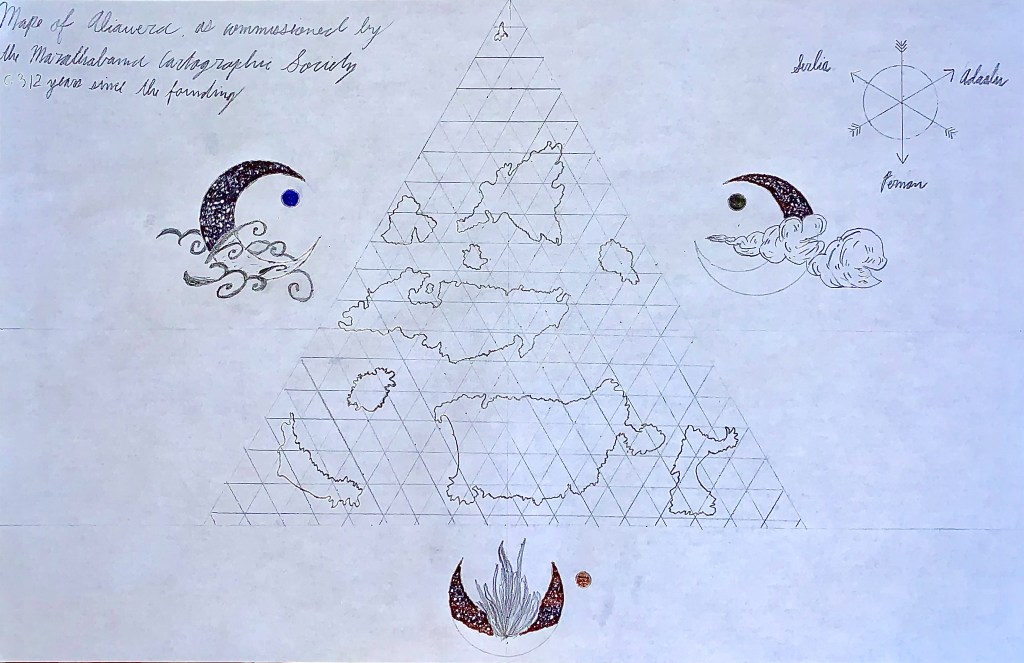
I still need to add some additional information to it, like a key or legend, and some specific locations and labels for the islands and cities on the islands. I might also include some kind of tide chart, or other informational inset that I think such a map might have. For now, consider this a sort of rough draft. Regardless of its artistic merit, I do think it accomplishes one important task: it conveys that the story to which it belongs is going to be set in a really unique world.

6 thoughts on “Maps and World-Building”